The digital data-sharing system aims to enhance uncrewed aerial flight safety and drive economic growth by positioning Northeast Ohio, and eventually all of Ohio, as a leader in the drone industry.

Baldwin Wallace University's Technology Partnerships Initiative, in collaboration with ATA, LLC, has launched the Northeast Ohio Flight Information Exchange (NEOFIX). The digital data-sharing system is designed to enhance drone safety, starting in Cleveland and Cuyahoga County.
NEOFIX provides real-time awareness of ground policies, infrastructure and activities that may impact flight operations, enabling state and local public safety agencies, government entities, drone pilots and the public to provide crucial information, promote transparency and ensure a high level of safety and accountability in drone operations.
Filling the gaps, unlocking potential
"Our goal with NEOFIX is to create a centralized hub for flight information that empowers responsible drone use and enhances situational awareness for both operators and public safety," said Stuart Mendel of Baldwin Wallace University's Technology Partnerships Initiative.
"By filling the gap between traditional aviation charts and street maps, NEOFIX unlocks economic prospects and positions Cleveland and Cuyahoga County as drone industry pioneers, prioritizing public safety and the rights of citizens and harnessing drones for advanced emergency response."
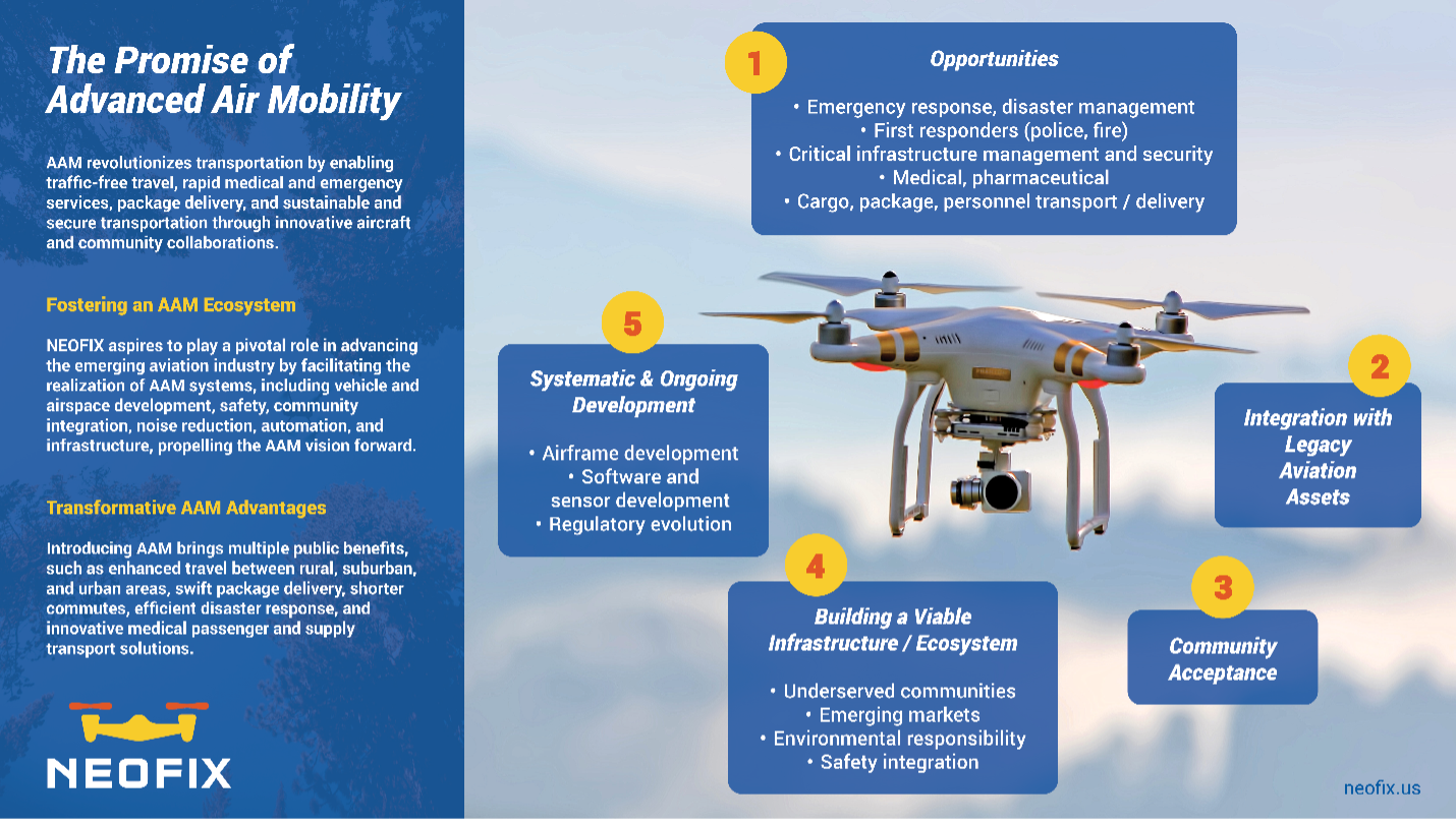
The graphic below elaborates on these promises, which can be expanded across Ohio.
Transformative centralized information hub
NEOFIX is an Authoritative Supplemental Data Service Provider (ASDSP) that provides the operators of drones, which are also known as Uncrewed Aircraft Systems (UAS), with essential information for informed decisions, operational efficiency and risk mitigation.
The centralized NEOFIX hub enhances collaboration, communication and safety for operators, public safety agencies, government entities, UAS Service Suppliers (USS) and the public. NEOFIX also offers access to safety advisories, weather assessments, local infrastructure details, topography insights and real-time updates.
As a shared governance model and authoritative source for clearer, higher-quality information that is critical for drone pilots, NEOFIX is an essential component for building a UAS Traffic Management (UTM) system. It provides a situational awareness of the ground that is sent to service suppliers for the drone industry that are currently developing UTM systems.
These commercial UTM systems are designed to operate like air traffic control in the close reaches of the airspace. They will soon be used for drones to fly greater distances beyond the visual line of sight of their operators.
"NEOFIX represents a transformative platform that empowers drone operators with comprehensive information, ensures safe integration, and fosters the growth and advancement of the drone industry in a cost-effective manner," said John Eberhardt, chief technology officer of ATA. "By embracing NEOFIX, operators gain critical data, promote regulatory compliance, and enhance drone safety."
Cuyahoga County leading the way

With support from Cuyahoga County District 2 Councilman Dale Miller, Baldwin Wallace secured $225,000 in funding for the inaugural year of NEOFIX from the federal COVID-19 stimulus package, which was part of the American Rescue Plan Act. This financial support sets the stage for the successful launch and implementation of the program and positions Northeast Ohio for private investment in infrastructure, education and jobs as the industry continues to expand in the region and eventually to the entire state.
NEOFIX helps to improve the safety and efficiency of using drones in various industries to drive this economic growth. For example, drones are used in construction to inspect buildings and bridges, reducing the need for workers to perform these tasks that are often dangerous, time-consuming and expensive by traditional methods. Drones fly over farmland, helping farmers survey their fields more quickly. First responders deploy drones to conduct search and rescue operations, deliver medical supplies and other emergency response missions.
Additionally, NEOFIX provides environmental benefits by creating infrastructure to support drone services in Northeast Ohio that reduce the need for larger ground transportation vehicles for deliveries. Drones are also powered by electricity or hydrogen, which are cleaner energy sources. And when integrated with sensor information, drones strengthen the area’s resilience against severe weather conditions and climate events, fostering a safer and more sustainable community.
Publicly owned and cooperatively managed
NEOFIX is a publicly owned digital service with data in the public domain, such as take-off and landing areas, critical infrastructure, local guidance and rules, and existing sensors. It uses an open interface for authorized users to publish key information.
A user group with representatives from state and local government and public safety agencies, service suppliers, and critical infrastructure providers will govern the system and identify the types of information that can be properly and consistently described and published. Private industry partners, including Critical Ops, LLC, an Ohio-based integration consulting firm, are helping guide and shape sustainable NEOFIX operations in Ohio.
“Government data provides a common operating picture, benefiting operators and industries. As information integrators, we facilitate the flow of data to end users as public digital services,” Eberhardt said. “Our model helps lower operating costs for operators, governments and industries while addressing their needs.”
Read independent reporting on the project at cleveland.com.
For more information about NEOFIX and public access to the system, please visit NEOFIX at bw-centers-tech-partnerships.org/neofix.
About NEOFIX
NEOFIX is administered by Baldwin Wallace University (BW) in Berea, Ohio, , with funding support from Cuyahoga County, Ohio. The data in NEOFIX is owned and managed by BW as a public asset for the people of Cuyahoga County. NEOFIX provides authoritative state and local data sharing for local and state agencies to UAS Service Suppliers (USS), Uncrewed Aerial Systems (UAS) and Advanced Aerial Mobility (AAM) operators. For more information, please visit NEOFIX at oh-fix.com.
About BW's Technology Partnerships Initiative
Baldwin Wallace University’s Technology Partnerships Initiative creates the conditions for technology and related businesses development to benefit the education and career opportunities of BW students, faculty and alumni in the region and Cuyahoga County communities adjacent and nearby to NASA Glenn Research Center and CLE Hopkins. The work products draw on the notion that BW will incubate social enterprise and engage public private partnership principles as if it were a nonprofit intermediary organization housed in a university setting. For more information, please visit bw-centers-tech-partnerships.org
About ATA
ATA, LLC (Advanced Technology Applications) is the full stack data solutions company focused on the DESIGN+BUILD of scalable, sustainable capabilities to improve organizational performance, optimize investments, reduce risk and use data as a strategic asset. ATA’s Aviation division is partnering with state and local governments to provide the digital infrastructure needed to safely integrate civil and commercial Unmanned Aircraft Systems (UAS) and Advanced Air Mobility (AAM) operations in the National Airspace. Visit ATA’s websites for more information at ata-llc.com and ata-uas.com.
About Critical Ops
Critical Ops is an integration consulting company founded in 2012, aimed at assisting organizations with major transformations, merger and acquisition initiatives, and project management. The company offers integration strategy and framework design services, leading functional teams, developing workstreams, and monitoring system transitions. Visit Critical Ops’ website for more information at criticalops.com.